Cairo: the park, the walls, the houses
The Aga Khan Trust for Culture is a non-government organisation based in Geneva that was set up in 1988 with the aim of promoting initiatives in the fields of culture, education and the safeguarding of cultural heritage in Islamic countries. It has a non-religious character and focuses on the economic, social and cultural development of the countries where it operates, financing itself both through its own funds and with trust funds from donators. The Trust is organised in three sections: the Aga Khan Award for Architecture, the Aga Khan Programme for Islamic Architecture and the Historic Cities Support Programme. The intervention currently underway in the centre of Cairo is part of this latter section. The activities supported by the programme are not limited just to planning and conservation interventions but tend towards improving economic, dwelling and environmental conditions of the local communities, setting up micro-credit companies, providing incentives for artisan production and offering professional training with the aim of creating skills and autonomous management structures for the future rehabilitation of the old area. In Cairo the sphere of action has been gradually extended from the creation of a major public park at al-Azhar – on the site of an old rubbish tip – to the restoration of the medieval city walls and the urban rehabilitation of the nearby old district of Darb al-Ahmar, densely populated and socially active. RC
Rita Capezzuto This great urban operation has brought about the design of a park, the restoration of part of the medieval city walls and the rehabilitation of a decayed building fabric. When did this project in the centre of Cairo begin?
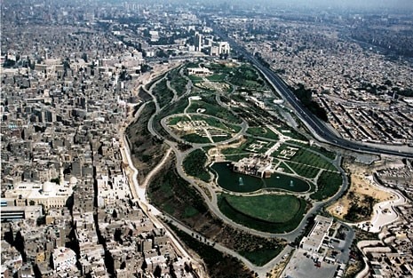
Francesco Siravo The project started with the idea of the new park that HH Aga Khan decided to donate to the city at the beginning of the 1980s, and was gradually extended. A site of around 33 hectares on the edge of the old medieval city walls was chosen. It had been used as a dump and was transformed over the centuries into a hilly area. Works for building the park led on to the excavation and uncovering of the ancient city walls. Architect Stefano Bianca, director of the Historic Cities Support Programme until a year ago, had always given careful consideration to the broader aspects of town planning linked to the operation and immediately identified the risks involved in the intervention. The park was certainly going to make a great improvement to the quality of the urban area, which had heavily deteriorated from both a physical and socio-economic point of view. But it would have also led to new unchecked urban developments, resulting in the demolition of antique buildings and perhaps the city walls themselves. The city walls are part of a vast system of fortifications built from 1176 onwards by Saladin, the founder of the Ayyubid dynasty that replaced the Fatimids as rulers of Egypt. Saladin hurriedly began a programme of fortifications for the entire city, which felt threatened by the presence of the Crusades in Palestine and other parts of the Middle East. The new walls, centred around the fortified citadel that still exists, went round the two original settlements of Cairo: the Fatimid city, part of which borders with the present al-Azhar park, and Fustat, which lies further south and is now known as Old Cairo.
So how did you proceed, based on the considerations you have just described?
The rubble that had accumulated on the site of what is now the park was mostly removed. In fact there was a problem of ground pollution so part of the land had to be replaced to enable the area to be planted afterwards. We also found ourselves faced with another difficulty that delayed building works. At the end of the 1980s three enormous water tanks had been placed in the dump area to collect water to supply the surrounding urban areas. These bulky elements of infrastructure were initially considered a negative feature but were then revealed as interesting from a design point of view, so much so that they were integrated into the landscape design. The park, completed in 2004 and costing around 30 million dollars, has been a great success. Today it receives an average of 3,000 visitors a day, increasing to 17,000 during Ramadan. It is used mostly by Cairo’s inhabitants – the tourists are a small minority – and has become a real place for social gatherings, regardless of class or economic status. The initial scheme was by Sasaki Associates Inc., an American group from Boston. The real design work, however, as well as the site supervision, was done by an Egyptian architect, Maher Stino from the practice Sites International. Beyond the city walls that run alongside the park is the old Al-Darb al-Ahmar district, where three areas were identified for rehabilitation.
How large is the district and what is the population density?
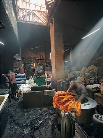
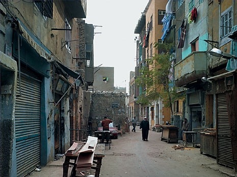
It is about 110 hectares with a density of 1,400 inhabitants per hectare and a total population of around 160,000. It’s the size of a small historic centre. One of the operations completed by Saladin in his fortification and rebuilding of Cairo was to connect the Fatimid city with the citadel, where he established his stronghold, with the creation of a main road called Darb al-Ahmar. Some of the most important mosques, palaces and commercial buildings in Cairo were built along this route, and during the Mameluke and Ottoman period the urban nucleus was constituted around this area, which was later to become the district of Darb al-Ahmar. The area is very interesting from an architectural point of view. There are 152 monuments protected by the Supreme Council of Antiquities (SCA). After an in-depth study of the area, we notified the SCA of the existence of a further 200 buildings of historical-architectural interest, both residential and commercial. The state of decay of this heritage area was considerable and made worse in 1992 when the area was damaged by an earthquake. Even before 1992, however, a steady fall in the area’s population had already been registered. Our study focussed on the possibility of salvaging the existing buildings and rebuilding on the plots that had been abandoned after buildings had collapsed. We calculated that around 16 per cent of the built fabric could be used for operations of urban integration. The ultimate aim is to maintain a stable population level that is capable of sustaining the district’s economy. We identified three areas for specific action, selected on the basis of their different characteristics and the presence of interesting elements such as monuments, public spaces or groups of minor buildings. At the end of the 1990s we found a disastrous situation. The poorest people in Egypt lived here, on family incomes of around 100 dollars per month. Despite this, Darb al-Ahmar was an area with a great deal of social and economic activity, with a large number of artisans and manufacturers, in spite of being marginalised with respect to those at the famous Khan al-Khalili bazaar, situated further north and considered one of Cairo’s principal tourist attractions. Many stall holders buy goods at Darb al-Ahmar such as furniture, objects in metal, inlay work, embroideries and fabrics. But because it is outside the main tourist routes, Darb al-Ahmar has kept its traditional character. A consideration of the positive and negative issues raised by the area gave rise to an intervention strategy that was aimed at guaranteeing the physical survival of the urban fabric and focussed on the economic reactivation and social rehabilitation of the district. One of the organisations affiliated to the Aga Khan Trust, AKAM (Aga Khan Agency for Microfinance) set up a micro-credit programme for the area’s inhabitants. At the same time a number of basic health and education services were offered and work was carried out to facilitate the direct participation of the inhabitants and the involvement of public institutions in the rehabilitation process. Finally we set up schemes for training builders, carpenters, plumbers, electricians and specialised artisans, many of whom were from the district itself, to be employed in an integrated urban renewal programme that included restoration work, repairing buildings, rebuilding public spaces and improving small-scale infrastructures (water supply, drainage, paving).
What work was done on the walls?
Did you come across anything of archaeological interest, such as layers of building?
We worked on a 1.5-kilometre-long section of city wall that runs alongside the park. Today this section of fortification has a height that varies between 2 and 12 metres and includes 15 defence towers and 3 important city gates that were uncovered and refurbished as urban connections between the district and the park. While the land was mostly imported, very disturbed and therefore not of great archaeological interest, some areas near the walls, particularly those corresponding to the old city gates, revealed complete sequences of layers. There is very little information regarding the walls, only historical research and photographs from between the 19th and 20th centuries. Work on the walls included archaeological digs, surveys, documentation of the damage, analysis of the materials and physical-structural conditions of the monument and actual restoration work that took a conservationist approach. Where it was inevitable that stones had to be replaced, blocks of stone were used with the same chemical-physical and aesthetic characteristics as the originals. When we came across previous restorations or changes that had been made over the centuries, these were kept and integrated into the new restoration, such as the internal parts of the walls that were already being used as dwellings or craft workshops during the Ottoman period. A study of the pathways established that about 80 per cent of the wall could be reopened to the public as a walkway, which has been partially equipped with facilities for visitors. Lastly, much importance was attached to the idea of how to present the ruins to visitors and the conversion of some internal spaces into museums. The interaction between the dwellings and the walls along with obstruction and occupation of the walls could already be seen during Napoleonic times, when the first map of the city was made. The houses encompass part of the fortifications but without going beyond them due to the rubble, which had already begun to accumulate during the Mameluke period. This condition continued up until the present and made it necessary to intervene not just on the monument but also on the houses associated with it. We worked in blocks and identified a building unit of around 190 square metres on 3 to 4 storeys. With the funds available, we have calculated that we can refurbish around 134 buildings by 2009. Sixty-five have been completed so far. New buildings to integrate parts of missing urban fabric or ruins are not included in this calculation. For each unit the average cost is around 25,000 dollars, or 130 per square metre. On average it takes four months to finalise the loans and building contracts and six months for works. During the works, residents move out temporarily and stay with friends or relatives.
How did the city react to your proposals? Did you get the consensus of the institutions and the inhabitants?
We always tried to work as much as possible in coordination with the institutions, even though in some cases we disagreed on approach and methods of restoration. In the example we just mentioned, the guidelines given by our Egyptian counterpart would have requested the demolition of the dwellings and the creation of an empty space around the old city walls. The idea of isolating monuments, however, is a 19th century idea. Now restoration goes in the opposite direction, towards salvaging the monument in its historic context. So with drawings and simulations we tried to demonstrate that demolishing the houses would have posed enormous problems in terms of the reintegration of the walls. This more up-to-date approach, also sanctioned by international papers on restoration, finally met with the approval of our institutional counterpart. As a result the restoration of the monument and the refurbishing of the houses went ahead hand in hand. As far as the inhabitants are concerned, we couldn’t have acted without their consensus. Apart from anything else they contribute about 30 per cent of the total costs. The remaining 70 per cent comes from the Social Fund for Development, a state-controlled Egyptian organisation that uses funds converted from debt made available by governments in Europe, especially Germany.
How were the apartments changed?
What kinds of materials were used for the rehabilitation? The layout of the streets and division of the land have remained the same over time. Darb al-Ahmar is an area that initially developed mostly in the Mameluke period (1250-1500). The bases of the houses are often in stone, which in some cases had remained intact. More recent additions were built on top of these, after collapses or building transformations that took place during the 19th and 20th centuries. The minor buildings are on long narrow plots. In other cases there are more important buildings with internal courtyards, built by important merchant families. A study of building types made it possible to establish restoration methods and forms of intervention. In general we have respected the overall typology and layout of the dwellings. The changes regard mostly the introduction of a bathroom and kitchen for each family unit to respond to the most pressing requests from the residents, often forced to share these services with other families. This programme of building rehabilitation is the first of its kind in Egypt. At the start we had to get over a certain amount of resistance that has now been overcome and the residents of the area are increasingly convinced. The technical offices of the Governorship of Cairo now also support the programme, which is considered a better and socially more acceptable alternative to the initial hypotheses for demolition or relocation of the residents. We started with the simplest cases where the inhabitants of the buildings were also the owners. Then we started dealing with the rented houses, attempting to meet both the expectations of the tenants and the requests of the owners, who, for the block on rents that dated back to the 1950s, could no longer afford the maintenance costs of the buildings. Traditional methods were used for the renovation with a lot of work done by hand. In some cases, especially with buildings that had undergone a great deal of change, prefabricated reinforced concrete beams were used in place of wood, made on site.
How long do you think it will take to finish the programme?
Rehabilitation work on this scale takes at least 20 years. Our intention is to create conditions for increasing capacity and economic, decision-making and building autonomy on the part of local institutions and groups, in such a way as to ensure continued investment and commitment to the refurbishment of the old city.
The conversation took place in Rome on April 27, 2007
Project coordination
(AKTC – Aga Khan Trust for Culture, HCSP – Historic Cities Support Programme) Luis Monreal (general director, AKTC) Stefano Bianca (emeritus director, AKTC) Cameron Rashti (director HCSP and Al-Azhar Park) Stefano Bianca (general director), Cameron Rashti (Al-Azhar Park), Francesco Siravo (restoration of the city walls and urban rehabilitation in Darb al-Ahmar), Jurjen Van der Tas (socio-economic programmes), Mohamed el-Mikawi (director and coordinator of the Cairo office of Aga Khan Cultural Services-Egypt)
Al-Azhar Park
Don Olson, Sasaki Associates Inc. (master planning), Maher Stino and Laila Elmasry, Sites International (landscape design), Rami el Dahan and Soheir Farid, architects (Hilltop Restaurant e ingresso principale_Hilltop Restaurant and main entrance), Serge Santelli, architect (Lakeside Cafè)
Restoration of the city walls
Elisa del Bono, Noha Nael Ahmed (coordination of the restoration team), Frank Matero, University of Pennsylvania (scientific supervision), Heba Mohammed Fouda, Robert Pilbeam (architecture), Ibrahim Bahaa, Guy Devreux, Josephine d’Ilario, Ashraf Labib, Angelo Lanza, Hussayn Mohsen Mohamed, Ali Mohamed Saeed, Giovanni Santo, Noha Sayed, Maser Sayed, Luc Tamburero, Mahmoud Yahya (restoration), Nora Abdel-Hamid Shalaby, Peter Sheehan (archaeology), Mamdoh Ibrahim Abdala, Hassan Abdel-Rahman, Sandro Amedoro, Ali Korani Ali, Mauro Musolino, Laurino Saccucci, Salem Helil Salem, Mahmoud Sayed, Abdel Aziz el Shishini (craftsmen)
Urban rehabilitation
Kareem Ibrahim (team coordinator), Jeff Allen, Seif el-Rashidi (town planning), Ayman el-Gohary (infrastructure), Hamad al Biblawy, Nevine George, Mahmoud Qotb, Mohamed Abdel Satar Sayed (architects), Mohamed Hamdy Abdel-Sattar, Samir Saad Mustafa, Hany Mohamed el Tayeb, Mohamed el Tayeb (site supervision), Awad Mohamed Awad, Abdel Fattah Hanafy Hassan, Gom’aa Abbas Nazir (craftsmen)