Denise's recollections 4/4

Concluding a four-part interview, Denise Scott Brown discusses recent work by VSBA in France, Morocco and the United States, expanding on the applications of mapping and the idea of joint creativity.

This interview with Denise Scott Brown, architect, urban planner and co-founder of Venturi Scott Brown Associates, was excerpted from one published 10 April 2011 in Domus China, in a series on women architects conducted by Brendan McGetrick.

Denise describes how growing-up in South Africa predisposed her to take an "African view of Las Vegas" and how study on three continents took her into urbanism and led her with, Robert Venturi, from Rome to Las Vegas and back to Rome, in search of an iconographic architecture of communication and an understanding of the automobile city. In the 1990s and 2000s when work brought them to Asia, Robert and Denise turned their research to Japanese and Chinese cities. Here she discusses their work in China and what they learned there, setting it within the context of their wider thought and lives.

This article concludes a four-part interview. Read part one, part two, and part three.

Brendan McGetrick: Which built projects do you feel represent important statements or breakthroughs for you?
Denise Scott Brown: In our office the first idea about an architectural project might be originated during campus and area planning. It's evolved as an indicative plan and pre-schematic design for a building or building complex that is central to the plan and whose working must be established early. I'm proud of the fact that it is my parti and can verify it by the location of the sketches — in our planning report and dated well before we had architectural contracts. That happened with the Dartmouth College library, the Penn Perelman Quad and the University of Michigan Life Sciences complex. But I have been involved in the conceptual design of almost all our major architectural projects and over the years a number of these have evolved from my parti.

At Franklin Court, a commemorative museum for Benjamin Franklin, there were two key concepts: one was to put the whole museum underground and convert the building site to a park to serve the dense area of town that houses the museum. A route through this park tied into the greenway system that Edmund Bacon, Philadelphia's planner, designed for the area. So we gave the city a park it did not expect. No fanfare heralded this idea and people may think the park was always there, but my heart leapt the first time I saw a man carrying a briefcase walking through it taking a short cut between sectors of the office world on either side. That was the first generative idea for Franklin Court and it had to do with activity patterns planning that I'd learned from urban economics. The second, which is noticed and loved by everyone, including me, was the "ghost structure" and that was Bob's. Our collaboration takes this form at times and at others we have different roles. And surely creativity is at play throughout the team and between us and the engineers. But both ideas were creative and their combination particularly so, and to say that an idea, let alone a building design, emerges from one mind only is not true. Frequently our ideas originate and grow through capping, his on mine, theirs on ours. Or one person has it and another sees its relevance.
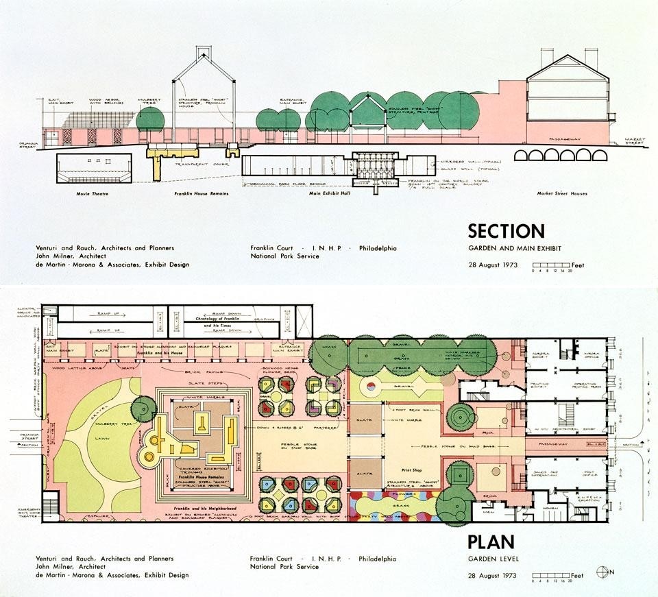
Top and above: Franklin Court and Benjamin Franklin Museum, Philadelphia, VSBA, 1976. Photo by Mark Cohn
So what is joint creativity? I can't define it but I recognize the elation when ideas zip back and forth across a table. I feel Bob and I work best when we work together, and I think he agrees. And in projects where time constraints have restricted our sharing, I see places where I wish I had been involved.
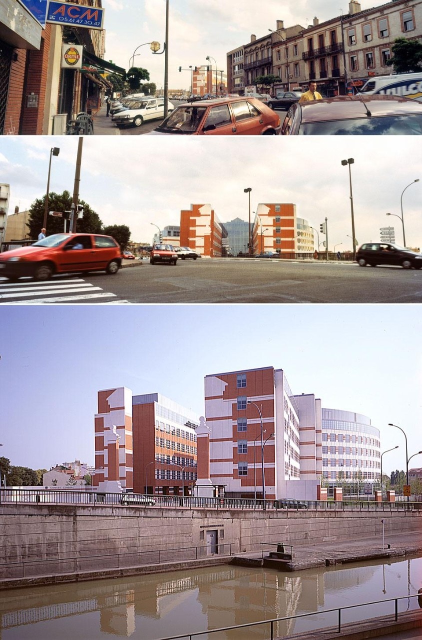
Urban plan, Hôtel du Département de la Haute-Garônne, Toulouse, France, 1990-99
On the subject of joint creativity, is there a pattern that you've established over the years; are there particular moments where you and Bob come together and intertwine your ideas in an active way?
It differs with different projects and often it happens when the two of us are away from everyone else. This is how it happened with our building in Toulouse: After we'd visited the site we gathered in Philadelphia with associate architects from Toulouse and New York to pour over a site plan showing a large piece of cleared land surrounded by a canal on one side, a busy arterial on another, and small medieval roads on the others. North and South of the site there were local shopping areas, one on the arterial as it approached the canal bridge, and another within a recent commercial development. One architect began the discussion by saying You could put a slab here, another this way, a third that way… It was as if he was furnishing a room: We'll put an armchair in this corner, a rug over here, and here will be the lamp.

Architects, lacking knowledge of urban activity patterns, economic relationships and how transportation works, look at a big site and ask, what should I do? By approaching a cleared redevelopment site as a big room they get way out of scale. I conceived of it as a continent or country, like China, across which ran the Silk Road, generating activities, whole cities, in fact, and relationships with its hinterland as it proceeded.
The trade route model suggests that you carry the streets of the site beyond its borders and link them to arterials in the region, near and far. Then you generate activities that go with the demand you've created at street crossings, placing intensely used parts of the project where its main "streets" cross and more private uses where there is less accessibility
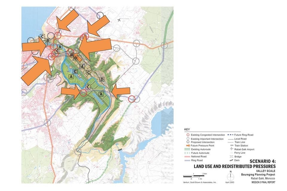
VSBA, <em>Land use and redistributed pressures study, Bouregreg Valley</em>, Morocco, 2003. <strong>A</strong> How were Scenario 4 decisions on
activities, land uses, buildings and
landscapes in the Valley made, and
what is their relation to the existing
and proposed transportation facilities? <strong></strong>How will the proposed disposition of
land in the Valley relate to the need
to alleviate congestion at the city
centers and to protect patrimony?
Scenario 4 proposes the location of
major new commercial and cultural
activities in areas that are already
congested. How will these areas
accommodate the even greater
numbers of persons who will need to
gain access to the new facilities? <strong>C</strong> How will the land uses shown serve
different users and relate to various
means of access -- to pedestrian
paths, vehicular circulation, the pathways
of tourists, and the routes of
commuters between home and work
in the region? <strong>D</strong> How will activities and the scale of
development proposed for the northern
portion of the mixed-use area
relate to what is around them, for
example, the planned convention and
cultural center, the lake and park, and
the river? How will they relate to
rocade No. 3 and the projected growth
of Sala al Jadida and Plateau
d’Akrache?
VSBA, Land use and redistributed pressures study, Bouregreg Valley, Morocco, 2003. A How were Scenario 4 decisions on activities, land uses, buildings and landscapes in the Valley made, and what is their relation to the existing and proposed transportation facilities? How will the proposed disposition of land in the Valley relate to the need to alleviate congestion at the city centers and to protect patrimony? Scenario 4 proposes the location of major new commercial and cultural activities in areas that are already congested. How will these areas accommodate the even greater numbers of persons who will need to gain access to the new facilities? C How will the land uses shown serve different users and relate to various means of access -- to pedestrian paths, vehicular circulation, the pathways of tourists, and the routes of commuters between home and work in the region? D How will activities and the scale of development proposed for the northern portion of the mixed-use area relate to what is around them, for example, the planned convention and cultural center, the lake and park, and the river? How will they relate to rocade No. 3 and the projected growth of Sala al Jadida and Plateau d’Akrache?
Planning for the Bouregreg Valley in Morocco, we treated the project first as a problem in urban regional development, building an infrastructure of movement related to economic and social policy assumptions, and limning out settlement patterns in relation to alternative policies and road systems. But in the client's office we saw the picture they had wanted. It was a site plan that purveyed a charming image of the Valley carpeted with small-scale, intricate buildings that resembled a souk. But the scale was off; any one building would have measured over 100 metres in length.

Population growth in Rabat and Saleh, cities at the mouth of Morocco's historic Bouregreg Valley, has precipitated development, some illegal, along its highways, threatening its ancient history and beauty, and diminishing the benefit it provides the region. An existing plan suggests various scenarios for the Valley floor but ignores the factors that cause illegal urbanism.

Our first map depicted existing congestion at traffic intersections and suggested areas of future pressure for growth, between the two cities and to the south, from in-migration of desert nomads. "What are the aims of the plan?" we asked, "And what government policies for regional population growth are you working to?" The reply was, "We don't know, no one knows," and agency members suggested that we architects were called in to paint a beautiful picture.
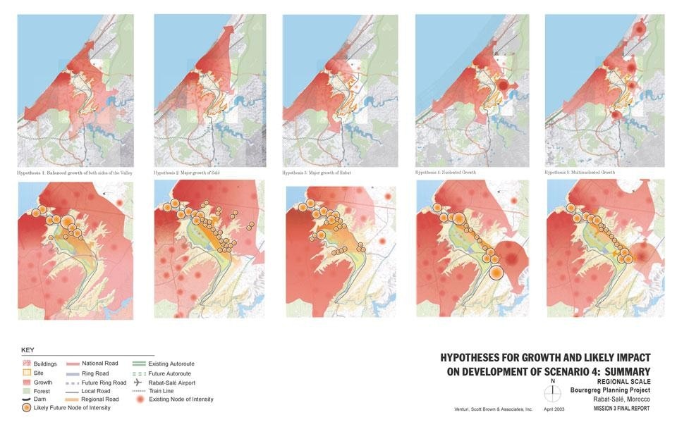
VSBA, <em>Hypothesis for growth and their likely impact on settlement patterns in the Bouregreg Valley</em>, Morocco, 2003. VSBA suggested five hypothetical policies for the settlement of populations, and generated a settlement pattern for
each, following the “city physics” assumption that growth would be drawn to nodes at larger and smaller roadway
intersections in the areas where the population settled. 
"Of course things don’t end there. Strong community goals, preservation of patrimony, for example, might influence
population policy; and now and then you can stand against the forces – make water run up hill. But you have to
be an excellent engineer, and there’s only one Central Park in New York. We suggested to our client that, in a
problem of this scale, the time to show attractive architectural visions was when policy options and their likely development
patterns had been limned out, and decisions among them were to be made."
VSBA, Hypothesis for growth and their likely impact on settlement patterns in the Bouregreg Valley, Morocco, 2003. VSBA suggested five hypothetical policies for the settlement of populations, and generated a settlement pattern for each, following the “city physics” assumption that growth would be drawn to nodes at larger and smaller roadway intersections in the areas where the population settled. "Of course things don’t end there. Strong community goals, preservation of patrimony, for example, might influence population policy; and now and then you can stand against the forces – make water run up hill. But you have to be an excellent engineer, and there’s only one Central Park in New York. We suggested to our client that, in a problem of this scale, the time to show attractive architectural visions was when policy options and their likely development patterns had been limned out, and decisions among them were to be made."
Could we do anything useful for them in the circumstances? We chose to show why a picture wouldn't help, and did so by illustrating our belief that social forces and road systems would determine settlement in and around the Valley.

Coming back to Toulouse, I said, one kindness you can do pedestrians is to draw a route across the site relating it to the shopping centres at either end and to uses beyond. This produced the "chicken bone" plan of a regional shopping centre and the "potential" model of urban economics. Gravity and potential models belong in "city physics." Here urban activities are likened to particles in physics and the potential for attraction between sets of them is investigated. Continuing, I said, the diagonal provides access and a short cut for pedestrians. There should be car entrances from the perimeter roads to below ground parking and the deputies' entrance to the Assembly. We want to set the buildings well within the site anyway, because they are big in comparison with the small houses and businesses of the area, and we should keep them low by spreading them out. So line the diagonal on either side with the administrative wings that must be reached by a walking public and connect them with each other over the diagonal with bridges. Then make gateways, some ceremonial some functional, from the perimeter streets.
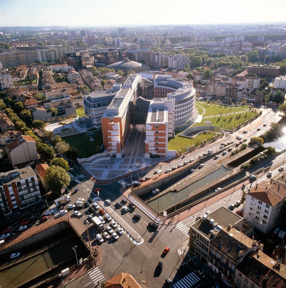
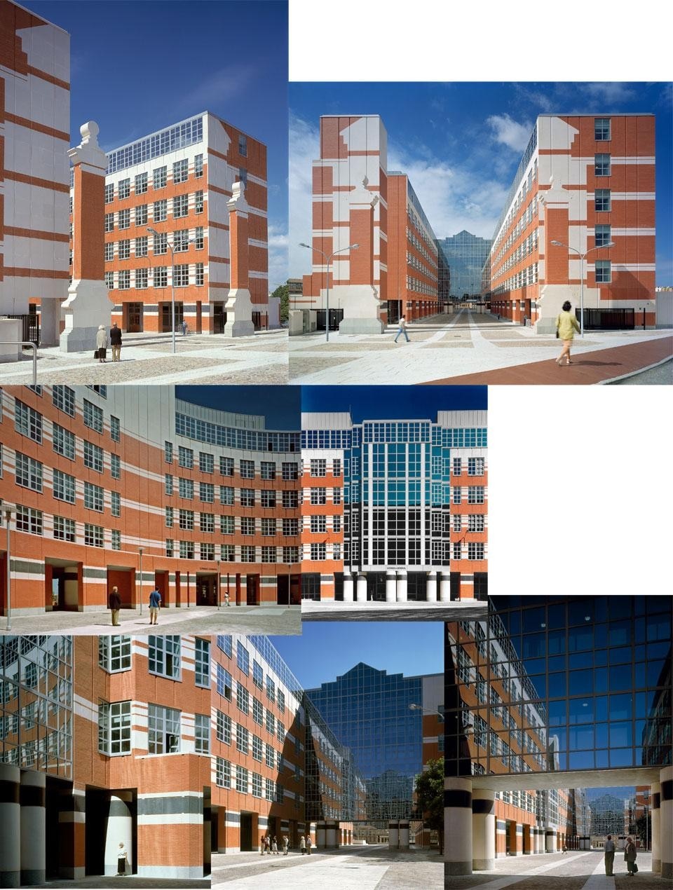
VSBA, Provincial Capitol Building (Conseil Général), Toulouse, France, 1999. Photo by Matt Wargo for VSBA
So with that we had the parti and the site was roughly zoned. Surely this was only a very small way into the design and its many beauties developed in the months that followed and well into construction, when we all worked on the project and its development. But its basis was a trade route pattern. This model suggests that you carry the streets of the site beyond its borders and link them to arterials in the region, near and far. Then you generate activities that go with the demand you've created at street crossings, placing intensely used parts of the project where its main "streets" cross and more private uses where there is less accessibility. Think of the Silk Route. Think of how cities grew up where main routes crossed. There is much more to a project than its parti, but the basics of the scheme were derived in that room out of these considerations. And they, in turn, penetrate to the inside of the building, so the smallest "coffee corner" is found at the crossing of two corridors.
VSBA, Provincial Capitol Building (Conseil Général), Toulouse, France, 1999. Distant view, north. Photos by Matt Wargo for VSBA
During construction we discovered an old map of the site before it was cleared for our project. It showed that our diagonal had been there before, exactly where we had placed it; naturally, since the "Silk Road" was, inter alia, a link between historic activities that had been there before and still existed.
VSBA, Provincial Capitol Building (Conseil Général), Toulouse, France, 1999. Photos by Matt Wargo for VSBA
Denise Scott Brown is a founding principal of Venturi, Scott Brown and Associates. She was born in 1931 in Zambia, grew up in Johannesburg, South Africa; attended Witwatersrand University, the London Architectural Association, and the University of Pennsylvania; and worked for architectural firms in Africa, England, and Italy. In 1960 as a faculty member in architecture and planning at the University of Pennsylvania, she met Robert Venturi, her professional partner and husband since 1967.

Denise has taught architecture, planning, and urban design at Penn, UC Berkeley, UCLA, Rice, Yale and Harvard, and has lectured widely. She has planned cities and towns; was campus planner for inter alia Dartmouth College, Brown University, the University of Pennsylvania, Harvard's Radcliffe Institute, and Tsinghua University in Beijing; and directed the University of Michigan's campus master plan. She led or contributed to dozens of design and planning projects for academic, civic, cultural, and municipal clients around the country and world, including Dartmouth's Baker Berry Library; Penn's Perelman Quadrangle; the Mielparque Nikko Kirifuri resort, Japan; the Conseil Général Building in Toulouse, France.

Her professional work, writing and research have influenced thought on architecture worldwide and are under reappraisal by students and a new generation of architects entering practice today.
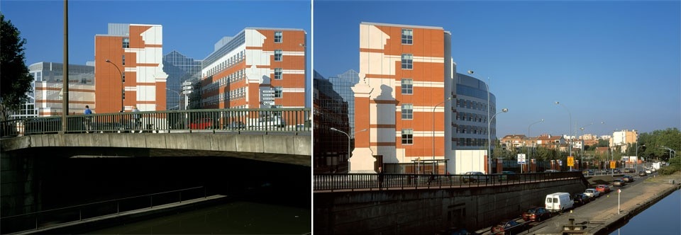
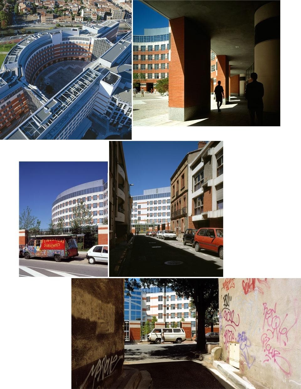
VSBA, Provincial Capitol Building (Conseil Général), Toulouse, France, 1999. Photos by Matt Wargo for VSBA

Most recent

Latest on Domus

Read more
China Germany India Mexico, Central America and Caribbean Sri Lanka Korea icon-camera close icon-comments icon-down-sm icon-download icon-facebook icon-heart icon-heart icon-next-sm icon-next icon-pinterest icon-play icon-plus icon-prev-sm icon-prev Search icon-twitter icon-views icon-instagram